In the previous lesson, we have learnt that the interior of the earth is very hot. Earthquakes and volcanoes are concentrated along a few narrow belts. The type and density of rocks of the crust are variable. The surface features are dynamic in character. This dynamism is due to two forces — endogenetic and exogenetic. Endogenetic forces are those which are caused from below the surface. Due to this, an area may get elevated or gets submerged. These forces try to make the surface irregular while exogenetic froces are those which operate from above the surface. They try to eliminate the irregularities of the surface through the process of denudation about which we will be reading in lesson. In this lesson we will be studying about the endogenetic forces.
OBJECTIVES
After seen this video, you will be able to :
- define isostasy
- describe the variation in relief features on the earth’s surface
- explain the isostatic adjustment by various experiments
- explain the views of Airy and Pratt and distinguish between the ideas of
- both; explain the concept of continental drift
- enumerate the evidences of continental drift
- explain the concept of plate tectonics
- identify and locate different plates on the world map
CONCEPT OF ISOSTASY
The term “Isostasy” is derived from “Isostasios”, a word of Greek language meaning the state of being in balance. You already know and must have seen that the mountain have many peaks and relatively great heights. Similarly plateau and plain have flat surfaces. They have moderate and lower height, respectively. On the contrary oceanic beds and trenches have greater depths. There is a great difference in height among these features. You also know that the earth is rotating while keeping perfect balance among its various features. Thus, our earth is considered to be in isostatic equilibrium.
Example:- Suppose you are holding one stick each in your both hands vertically with varying heights, say 5’ and 15’ and you are moving in a particular direction. Do you have any difficulty in maintaining a balance in congruence with your body as well as two sticks together? Definitely, smaller stick will be easy to make a balance than the longer one. It is just because of the centre of gravity. The centre of gravity with smaller stick will be nearer to your holding hand in comparasion to the longer stick. In the same way smaller surface features like plains are more stable than the tall mountains.
A. Isosatic Balance: views of Airy
Airy, a geologist, considered the density of different columns (plains, plateaus, mountains, etc.) to be the same. Hence, he proposed the idea of ‘uniform density with varying thickness’. We know that the upper crust of the earth is made up of lighter material. In this layer, silica and aluminium are found in abundance, hence it is known as ‘Sial’. It is less denser than the lower one. Airy assumed that the Sialic crust is floating over the Sima (silica and magnesium, lower denser layer). Crustal layer is uniform in terms of density with varying length of columns. Therefore, those columns are projecting down into the asthenosphere depending upon the proportions of the column. It is due to this reason that the root has developed or the sima has been displaced from below.
DYNAMIC SURFACE OF THE EARTH Chapter 3rd
To prove this concept, Airy took an example of wooden blocks of various sizes and immersed them into water (Figure 3.1). All blocks are of same density. They get immersed differently in proportion to their sizes. In the same way higher features with great height seen on the surface of the earth have deeper roots whereas short in length has shorter roots beneath. It is the concept of root which is sustaining the higher elevation. He is of the openion that the landmasses are floating like a boat in the substratum (magmatic asthenosphere). According to this concept, the root beneath the Mt. Everest would be 8848X8 = 70784 metre below the sea level. On this bases Airy has been criticized that the root is not possible to be at such a great depth. Because the root material will melt due to higher temperature found at that depth.

B. Isostatic Balance: views of Pratt
Pratt considered landblocks of various heights to be different in terms of their density. The taller landmass has lesser density and smaller height features to be denser. In other words, there is an inverse relationship between height and density. If there is a higher column, density will be lesser and if there is a shorter column, density will be higher. Assuming this to be true, he accepted that all blocks of different height get compensated at a certain depth into the substratum. In this way a line is being demarcated above which there is equal pressure with varying heights. Thus, he denounced the root concept of Airy and accepted the ‘concept of a level of compensation’. For proving his concept he took a number of metal bars of varying density with same weight and put them into mercury (Figure 3.2). In this way they form a line by all those bars, which he regarded to be the level of compensation.

Differences between the views of Airy and Pratt
The differences between the views of Airy and Pratt can more clearly be presented in a tabular form:-

C. Global Isostatic Adjustment
It is quite apparent that there is no complete isostatic balance over the globe. The earth is unstable. Endogenetic forces often disturb the crustal balance. The regular earthquakes and volcanic eruptions along a particular belt do not signify any balance but a sort of adjustment is needed continuously. Endogenetic forces and their tectonic effects are the causes of imbalance on the surface but nature always tries to make an isostatic adjustment with itself.
Exogenetic forces are trying to eliminate the differences on the surface of the earth and in this process they are peeling off, transporting down to far flung places, and depositing them. In this process, isostatic balance is maintained by the underneath flowage of material by subsidence at the place of deposition and upliftment at the peeling of place in their proportion to the denudation.

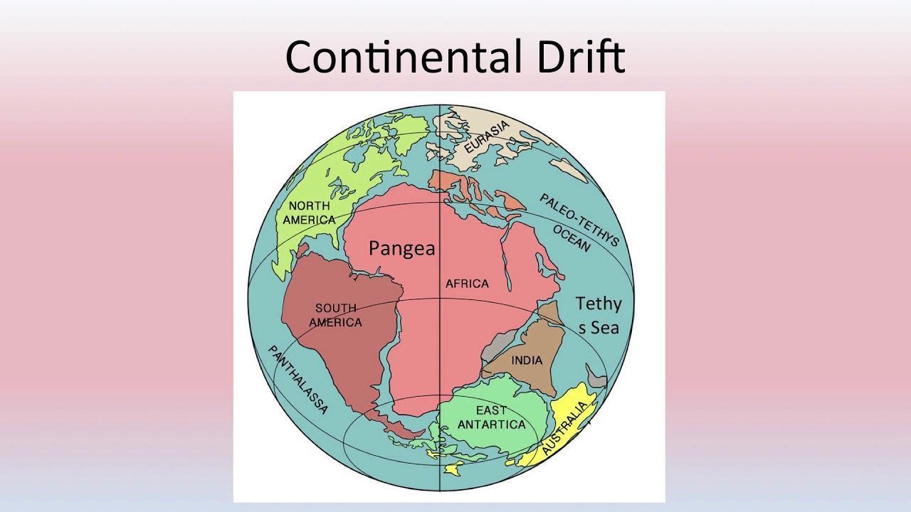
CONTINENTAL DRIFT
According to Alfred Wegener, the entire landmass of the globe was together about 280 million years ago. It was termed as Pangea, a super continent. The huge water body surrounding the Pangea was known as Panthalasa. From 280 to 150 million years ago, Pangea was broken latitudinally into northern and southern parts known as Laurasia (Angaraland) and Gondwanaland, respectively. Both of them drifted away and in between a shallow sea emerged by filling up the water from Panthalasa. It was known as Tethys sea. Later on Laurasia and Gondwanaland rifted and finally drifted to form the present day distribution of land and water on the earth.

Evidences of Drift
Wegener gave a number of evidences in support of the unification of landmass in geologic past. They are such which cannot be negated even today
a. Jig-saw-fit – Eastern coast of South America is identical to Western coast of Africa which fits to a certain depth in the ocean. To a certain extent coastal areas and continental shelves have been modified by oceanic waves through denudation
b. Geological similarities – The mountain systems of Southern Atalantic coast in South America and Africa show the similarity of the extension in both continents.
c. Coal and Vegetation evidences – The distribution of coal and vegetation over South America, Africa, India and Australia proves that they were together in geological past. The classical glacial deposits during carboniferous period over these landmasses resemble each other which tells the story of togetherness. Today they lie in different climatic zones. Apart from above evidences put forward by Wegener, other evidences (known later) are also there which support the idea of continental drift.
d. Evidences from paleomagnetism :– Paleomagnetism is the study of the direction of pole through ages. Magnetically susceptible minerals like haematite, pyrhotite magnetite etc. get aligned with the magnetic pole of the earth and recorded in the solidification of magma during that time. It is found that periodic changes have occurred and poles have wandered which is not possible for the entire earth. Hence, it is the twist and turn of the landblock and not for the entire earth which has again explained that the continents have shifted their positions.
e. Sea floor spreading :– Along the mid Atlantic ridge, magma comes out at the sea bed and gets solidified. A new zone is formed and this process is continuing since millions of years. It is leading for diversion of continental block, and hence the size of the Atlantic ocean is increasing which is termed as sea floor spreading. It is the classical example of the shifting of continents. The explanation of continental drift through sea floor spreading and the study of paleomagnetism is commonly known as Plate Tectonics.
PLATE TECTONICS
The uppermost outer solid and rigid layer of the earth is called crust. Its thickness varies considerably. It is as little as 5 km thick beneath the oceans at some places but under some mountain ranges it extends upto a depth of 70 km. Below the crust denser rocks are found, known as mantle crust. This upper part of mantle upto an average depth of 100 km from the surface is solid. This solid mantle plus upper crust form a comparatively rigid block termed as lithosphere. Mantle is partially molten between 100 to 250 km depth. This zone is said to be asthenosphere, also known as Mohr discontinuity, a simplification of Mohorovicic, the name of the seismologist who discovered it. All these things you have already read in the previous lesson.
Mechanism of plate Movement
Arthur Holmes, a British geologist, in 1928 – 1929, proposed that convectional currents exist underneath the lithosphere. The centre of convectional current is not exactly known, but it is believed that it has an average depth of about 100 to 250 km below the surface. The inception of the current is initiated by heat generation due to radio-active minerals. Due to integration and disintegration of atomic minerals heat is produced and hence the melting of surrounding rocks. In this way currents start operating. These currents are classified into rising and falling with divergence and convergence activities, respectively.
With rising convectional current, transport of hot and viscous matter takes place upwardly. After reaching about 100 kms below the surface that current gets diverged leading to split into the upper part. The molten material penetrates into the split and thus creation of new surface and the draft of the mammoth plate in opposition direction. It happens below the mid-oceanic ridge. On the other hand two sets of diverging thermal convectional currents brings two plates together and it is called convergent boundary where subduction takes place. Plates of lithosphere are constantly in motion because of convectional currents. Their relative motion depends upon the force operating over them.
Plate Tectonics Vs Earthquakes and Volcanoes
The distribution of earthquakes and volcanoes over the globe (Figure 3.9) clearly reveals that they are strongly associated with the boundaries of plates. Plate boundaries are the zones where every sort of tectonic activity does take place. The release of energy created because of the movement of plates is manifested in this zone in the form of earthquakes and volcanic eruption.